MileValue is part of an affiliate sales network and receives compensation for sending traffic to partner sites, such as CreditCards.com. This compensation may impact how and where links appear on this site. This site does not include all financial companies or all available financial offers. Terms apply to American Express benefits and offers. Enrollment may be required for select American Express benefits and offers. Visit americanexpress.com to learn more.
Note: Some of the offers mentioned below may have changed or are no longer be available. You can view current offers here.
Hey there, you’re reading an outdated post! The updated series from April 2015 can be found here.
This is the twenty-third post in a monthlong series. Each post will take about two minutes to read and may include an action item that takes the reader another two minutes to complete. I am writing this for an audience of people who know nothing about frequent flier miles, and my goal is that by the end, you know enough to fly for free anywhere you want to go.
The Great Circle Mapper is a valuable free, online resource that can be found at gcmap.com. It is a simple mapping tool that can shed light on your itineraries.
On any page, you can type airport codes into the text box. If you separate two codes with a dash, a straight line will be drawn between them and the distance of the flight given. A comma can be used to separate airport codes between which you will not be flying.
After typing in the codes separated by the appropriate dashes and commas, click Distance.
Now you have a cool map of your upcoming trip with the distance of each segment and the total distance listed below. Beyond its coolness, I use Great Circle Mapper for several reasons.
If you want to know how the distance of an itinerary changes by adding stopovers or changing the routing, it’s a a great tool. This is important if you are trying to earn miles from flying paid tickets, and you want to see how many miles each routing earns. Most airlines’ official distance between two airports corresponds almost exactly to Great Circle Mapper’s distance.
Another reason you want to know the distance is to know how many Avios would be needed for an award flight between two cities. Because Avios is a distance-based award program, you need to know the distance of each segment to know how Avios will price an award.
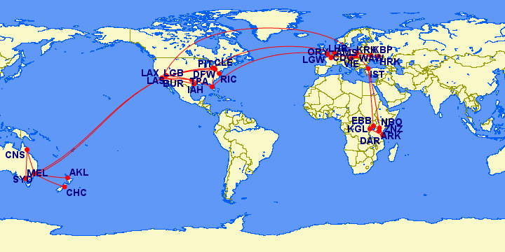
And my favorite reason to use it is to visualize all the free first class I’m flying. Here’s my flights flown or booked for 2012 and 2013, and hopefully I’ll be adding more soon because I see big holes is Asia and South America!


Another great and similar tool for looking at One World flights is the One World ineractive map. It will show all available routings out of each city on OW carriers. It’s handy when you’re trying to create an itinerary to burn your AA or BA miles.
This is indeed a excellent tool. Lots of features to use and take advantage of. Worth sharing.